
Category: Weather

Signal 10: Hurricane Hato bearing down on Hong Kong
The Observatory has raised the no. 10 hurricane signal as Typhoon Hato, bearing winds of 155 kmh, heads for Hong Kong.
If Hatao stays on track, Lantau could take close to the full force. The typhoon is tracking toward the Pearl River Estuary and forecast to reach as close as 50km south of the city.
The Observatory has reported maximum sustained wind speeds of 155 kmh.
All schools, bus and ferries are closed and dozens of flights have been cancelled.
The MTR is running a very limited service, with no airport express and no service on the Tung Chung line except between Hong Kong station and Kowloon.
The Observatory raised the no. 10 signal at 9:10am, an hour after raising the no. 9 signal which indicates sharply inceasing wind speeds. It has also posted an amber rain warning.

It warns of “severe sea water flooding” in low-lying areas and urges people to stay away from the shoreline and stay indoors.
At 9am Typhoon Hato was about 80 kilometres south of the city and forecast to move west-northwest at about 25 kmh toward the Pearl River Estuary.
In the past few hours, local winds were strengthening significantly. Storm force winds are affecting offshore waters. In the coming few hours, Hato will be closest to the territory, skirting about 50 kilometres to the south of Hong Kong. When the local winds strengthen further, the Observatory will consider issuing a higher signal.
The hurricane signal no. 10 has only been raised twice since 1984 and was last issued in 2012 for Typhoon Vicente.

Flights cancelled as Typhoon Hato heads our way
After days of sweltering heat, Hong Kong is bracing for Typhoon Hato.
The Hong Kong Observatory (HKO) hoisted the strong wind warning signal this afternoon and says it may raise the T8 at around midnight. The T1 warning has been current since 8:40am.
Already dozens of flights have been affected. Most Cathay and Dragon flights scheduled to arrive or depart between 6pm and 5am Wednesday have been cancelled, Cathay Pacific said.
Hato is likely to be closest to Hong Kong tomorrow morning, bringing with it sustained wind speeds as high as 130kmh.

Hato’s expected course (HKO)
At 6pm, Hato was an estimated 410 kilometres east-southeast of Hong Kong and expected to move west-northwest at about 25 km/h.
The HKO’s new cyclone tracker says the typhoon has an 80% probability of hitting Hong Kong. Observatory senior scientific officer Queenie Lam Ching-chi told SCMP.com:
“Hato will definitely pose a threat to Hong Kong. With an intensity of 130kmh at its centre, it has all the conditions to develop into a stronger storm,” she said. “But a higher signal will depend on the data we obtain on its movement and wind structure.”
With the approach from the southeast Hato will be felt most strongly in low-lying coastal areas, including Lantau.
Even if Hong Kong avoids the worst of Hato, the Observatory predicts a week of cloud and rain..

Outlook: rain (Source: HKO)
The Observatory said its Tsim Sha Tsui headquarters early this afternoon had recorded its highest ever temperature – 36.6 degrees.

T8 signal to be hoisted as Typhoon Roke approaches
The Hong Kong Observatory says it will hoist the T8 signal by 9:20 this morning as Typhoon Roke approaches the city.
It says Roke is relatively small but warns wind speeds will strengthen as it approaches.
At 8 a.m., Roke was estimated to be about 90 kilometres east of Hong Kong east and expected to move west-northwest at about 20 kmh.
In the past few hours, Roke brought gale winds to the coastal waters of the eastern part of Guangdong. The circulation of Roke is small, but local winds will strengthen significantly when Roke moves close to Hong Kong…
As Roke will very likely track from east to west across our territory, local winds will turn rapidly from the current northerlies to south and southeasterlies. Places which have been sheltered before will become more exposed to the high winds. The public should stay on the alert and not to relax precautions.
The T3 signal was raised at 3:40 am.


Another amber storm warning as rains lash city
The amber rainstorm warning was hoisted late this afternoon for the second time today as heavy rains continued to lash Hong Kong.
A southerly airstream brought more than 40 millimetres of rain across the territory this afternoon, with more than 100mm falling on Kwai Tsing District, the Hong Kong Observatory reported this evening.
Areas of central and northeastern parts of the New Territories reported widespread incidents of flooding.
The Observatory says over the past 24 hours parts of Lantau received as much as 200 millimetres of rain, with Tai O in the west and Disneyland in the northeast both receiving between 150-200 mm. Much of southwest Lantau and Tung Chung received slightly less rain – between 100-150mm, the Observatory data shows, with the heaviest falls between 2-5pm.

Chart: HK Observatory
The amber rainstorm warning, issued at 4:20pm, remained in force at 8pm. It indicates a likely fall of 30mm or more in an hour.
The earlier amber signal was raised at 8:20 am and cancelled at 11am.
The Observatory predicts further “heavy showers and a few squally thunderstorms” tomorrow morning, with some sunny periods in the afternoon.

Lantau cab driver arrested for overcharging during typhoon
A taxi driver called Ho must be one of the unluckiest people in Hong Kong.
The 60-year-old Lantau taxi driver was arrested by police last night for overcharging fares during Typhoon Merbok, HK01 reported today.
Following complaints about cabs refusing fares and hiking prices during typhoons, plainclothes officers went to the Tung Chung MTR taxi stand at 5pm, just before T8 was hoisted.
A cab driven by Ho arrived at the rank and, after asking their destination, he allegedly asked for a fare well above the standard price.
Ho was arrested under section 40 of the Road Traffic (Public Service Vehicles) Regulations, which forbids a driver from asking for an inducement, with a penalty of a $10,000 fine and six months jail.
This police sting might prompt surprise among regular customers of Lantau cabs, where soliciting for higher fares is a widely-reported practice.
Among Hong Kong taxis in general, raising the price during the typhoon is also not unusual because of the limited number of cabs and the urgent demand. The arrested driver can count himself unlucky.

Lantau unscathed as Typhoon Nida heads inland
Lantau residents dodged a bullet overnight as Typhoon Nida passed without incident. No injuries or major damage were recorded, Lantau police said.
Across Hong Kong only three people sought hospital treatment, RTHK reports.
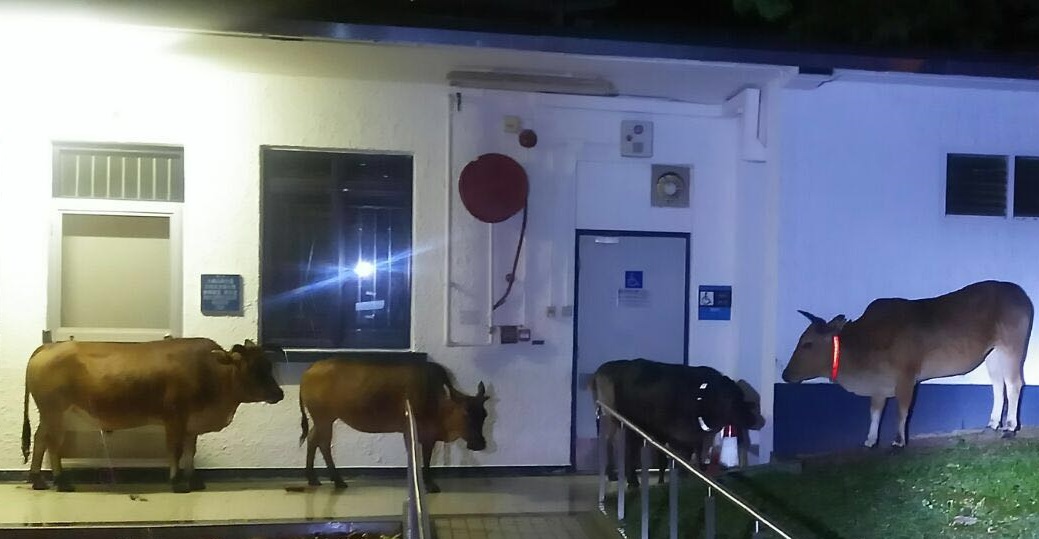
Cattle take shelter at the Cheung Sha police base
Hong Kong Observatory replaced the T8 signal with the T3 strong wind warning at 12:50 pm. Continue reading

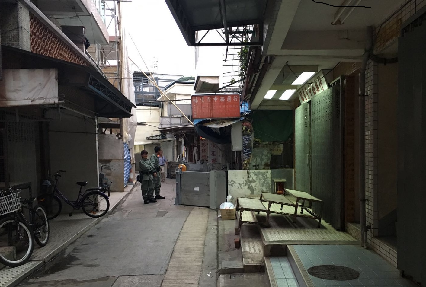
Tai O residents evacuated over flooding fears
Police have moved dozens of Tai O residents to an overnight shelter because of the fear of flooding from Typhoon Nida.
Battening down in Tai O Source: Lantau Police
Inhabitants of approximately 500 stilt houses, built over the water at Tai O, shifted to an emergency shelter provided by the Tai O Rural Committee in Market St, police said. Continue reading

Nida set to pass northeast of Hong Kong
Typhoon Nida has shifted course over the past 24 hours and is set to pass to the north-east of Hong Kong.
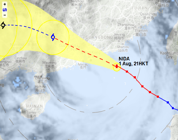
Hong Kong Observatory satellite map, 9pm
After hoisting the Typhoon 8 warning signal at 8:40pm, the Hong Kong Observatory said Nida would close in on Hong Kong overnight but its centre would pass within 100 km to the northeast of the territory.
It warned the typhoon would bring a storm surge that is likely to bring flooding in low-lying areas. That will put Lantau’s Tai O and beachfront properties on Pui O Beach and Lower Cheung Sha at risk. Continue reading

Typhoon Nida to make direct hit on Lantau
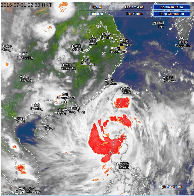
Satellite image at 10:30 HK time, Sunday. Source: HK Observatory
Lantau will take the full brunt of typhoon Nida, according to Hong Kong and international weather services.
The Hong Kong Observatory (HKO), US National Hurricane Centre and the Korea Meteorological Administration all predict Nida will strike Lantau Island, according to the Weather Underground (below).
